News
Last Update :7/22/2011 Golf Course Documentation in 3D
Golf courses are intensively managed landscapes requiring substantial inputs of expertise, labor, materials and energy. The challenge of maintaining healthy turf is additionally complicated by environmental and budget constraints.
To inform critical operational decisions, superintendents rely on professional training, site experience, management records and facility maps. Maps are important documents of the physical assets of the golf course for many reasons. Typical sources for the facility’s map are the original design plans, as-builts mapped by GPS, or aerial photo mapping.
Area measurements taken off the course map are used throughout operations – for agronomic applications, contracting services, ordering materials and planning budgets. Also important are distances and locations of drainage, irrigation and other course system assets that are plotted on these maps.
New mapping technologies offer higher accuracy and capture new dimensions of the course, providing superintendents with better information to work with. Existing as-built maps produced by resource-grade GPS or aerial mapping can have 5-30% errors in positions and areas. This error introduces uncertainty in management equations and tends to result in overages in applications and costs.
Survey-grade GPS, accurate to the inch, and laser-based instruments now enable the golf course to be mapped accurately and rapidly. A primary benefit is that area measurements are then effectively 100% accurate. Establishing this precise quantity baseline is especially important now with pressures to cut agronomic inputs and costs.
Also, the position of system assets, above and below ground, can be exactly located, and recovered, minimizing excavation damage and disruption of play.
The new facility map is, of course, created in digital form, for easy storage, access, editing and sharing. The map software may also include analysis functions, and the map can be used in the field on handheld GPS computers, including Smartphones, as well as hardcopy.
The latest mapping technology – the 3D Laser Scanner – enables the complex shapes and subtle slopes of the golf course (the design asset) to be mapped. More accurate than GPS, and able to map millions (literally) of topographic points in a day, the laser scanner can produce a virtual model of a golf course in high definition.
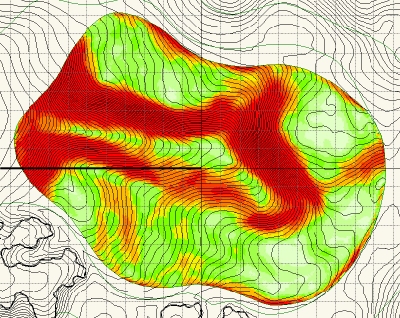
There are numerous applications for the 3D golf course model. The first one of interest to designers is the ability to generate a true (not interpolated) green’s surface map showing slope classes which are essential to know for re-design with newer faster hybrid turf varieties.
Superintendents appreciate the true shapes, areas and slopes of the green and this information is used to produce the most complete pin rotation schedule that allows for turf recovery, shot values and reduces uncertainty (and controversy) in determining pinable areas and fair hole locations.
These greens models are also essential information in planning careful

Pic 1 – Modeling of Ballyhack’s 18th green reveals subtle shapes and distinct cupping areas.
renovations and enabling faithful restorations. Using this new information can resolve most concerns about losing the original character of the green in the renovation process because the true character of the green is well documented.
Consider how such a document would have benefited the restoration of Pinehurst #2. Extensive searching for remaining plans and photographs gave clues to the original design. But accurate as-builts were not available then, and so, interpretation was required. Future restorations of classic and newer courses will have the benefit of accurate 3D modeling to work with making restorations much easier and less costly.
In the future, 3D documentation of all courses will build a library of materials for all students of the game.
Davis Wildman is CEO of TerraVea, VGCSA’s newest corporate partner.
[ More News ]
|
